What is Free Route Airspace?
Free Route Airspace (FRA) is an airspace within which airspace users may freely plan their routes between an entry point and an exit point. It was introduced in Europe to give airlines better flight routing opportunities than could be achieved with the fixed route structure. Free Route Airspace was also mandated under the EU ‘pilot common projects’ regulation: EU 716 (2014).
SESAR Solution #33 further describes ‘free routing’ as “the ability of an Airspace User to plan/re-plan route according to the User defined segments (i.e. segments of great circle connecting any combination of two user defined or published waypoints)”.
Implementing FRA has not been a simple matter, requiring traffic simulations to ensure that the airspace did not introduce multiple conflict points from unpredictable entry and exit points into the free route airspace.
The potential benefits of FRA were believed to be considerable, with various benefits estimated at 1.3%1 of up to ~2%2 of flight distance at the network level. Implementation did not require new technology, just changes to airspace and operations, creating a strong business case for it.
So, what’s wrong?
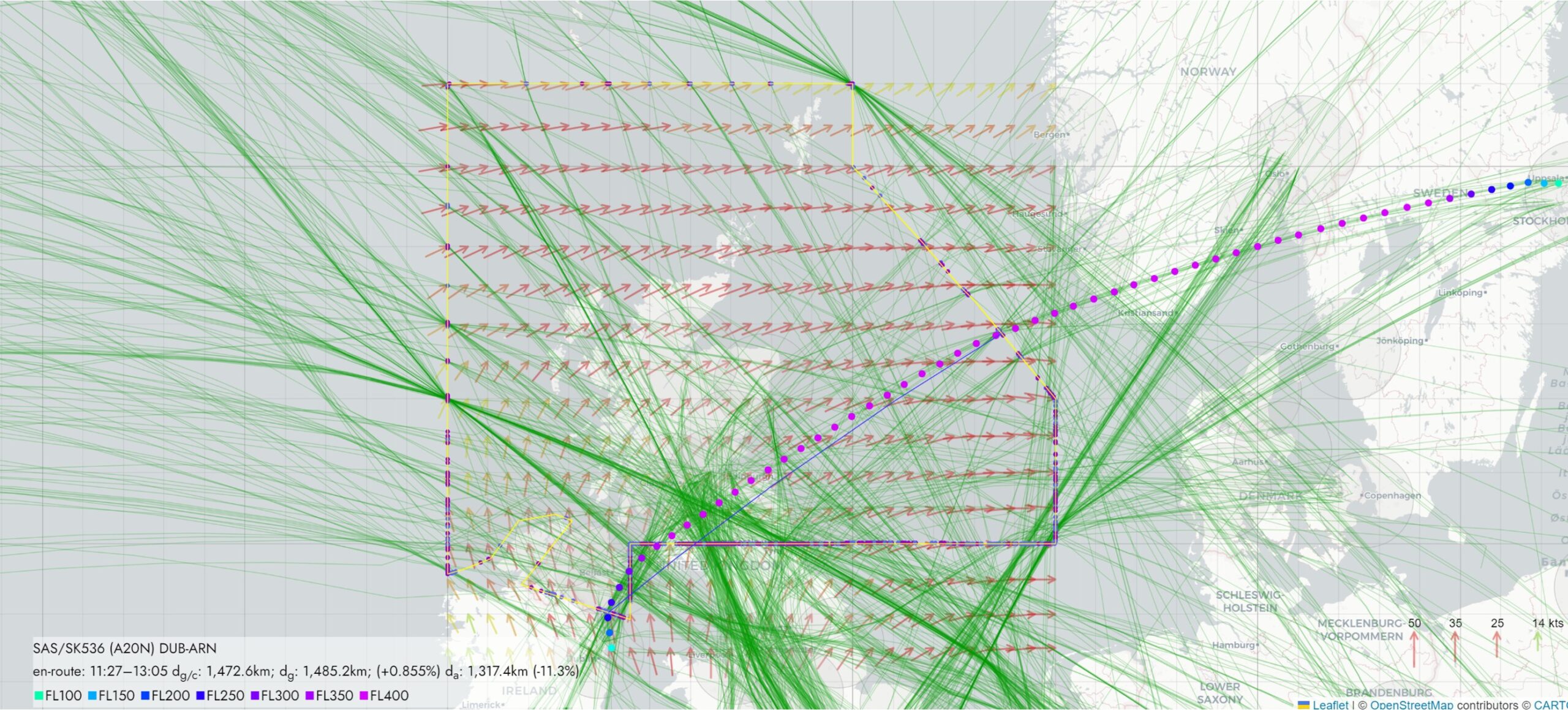
We were intrigued that most flights through FRA seemed to be direct from entry to exit point, with little other variation. In comparison, our AirOpt simulation tool in ‘freely routing’ mode shows a variety of routes, based on a high density of nodes (waypoints). For example, when optimising flights around highly modular special use airspace (SUA) designs or simulating the effect of enroute charge modulations (reference SES 2+). We can also clearly see the effect of charges on airline routing, so why not winds? (See the NE corner of the Scottish FIR in the figure below for flights that take a 30° turn as they skirt the higher FIR charges.)
By analysing ADS-B flight tracks we confirmed them to be mostly direct through FRA, meaning that they follow the shortest distance between two points on the earth, known as a great circle.
An issue for most simulations and cost benefit analyses over the last ~25 years is that it is assumed that the wind has no effect on routing, or that winds average out. It is also difficult to include the winds without sophisticated computer models and high power processing. In other words, the ATM system appears to be designed and measured in still winds but operated in a wind-variable world. This is why we developed the ‘Air Distance’ metric, in various forms, presented later in this article.
Our hypothesis was that free route airspace has become direct route and that, if so, there is an opportunity for increasing flight efficiency by getting free routing ‘back on course’. To explore the issue we have studied ADS-B tracks from Plane Finder through the Scottish FIR. The figure below shows tracks from 25 January 2025. It is striking that the majority of the tracks closely follow the great circle from entry to exit point of the FRA. A track is highlighted (coloured dots) that diverges from the great circle slightly, shown by the blue line. This may show some wind based routing but it is hard to tell from this data.
Figure 1: Example routing through Free Route Airspace (Scottish FIR)
We concluded that we had some evidence of direct routing being the norm and decided to consult experts within the industry, including with flight planning experts. We also compared horizontal flight efficiency (HFE) measurements using ‘ground distance’ and ‘air distance’. This led us to see that there are three parts to this story: computerised flight planning systems, route ‘availability’, and flight efficiency measurement.
Computerised flight planning systems
Computerised flight planning systems came into being in the 1990s. Computers made wind-based routing a reality, advised pilots on how much fuel to carry, navigate ATC and regulatory rules and generally save substantial amounts of fuel per flight. Free route airspace was to play to the strengths of these systems. However, the thing that makes flight routing algorithms work was also being taken away – the waypoints and the routes between them. We try to explain how this works in Box 1, but note that the flight routing algorithms only work when they have nodes (waypoints) and edges (airways) to route along. Taking away the nodes (waypoints) is not like going off road in a 4×4, it’s like seeing a hole in the road ahead and having to go back to the start to take a different route.
Box 1: How routing works for flight planning
The basis for determining the route of a flight is a branch of mathematics called ‘graph theory’. Its most famous algorithm was developed by Edsgar Dijkstra in 1956, which was conceived to solve the problem of the shortest path between two points. This is still widely used today, although a wide range of alternative algorithms have been developed to speed computation. Shown in the figure are two possible routes between points A and B. The green circles are ‘nodes’ of the graph and the lines between them are ‘edges’. The edges are ‘weighted’, with the numbers shown, which may simply be the distance between the two points, but often this is more complicated. So in flight planning, the weights may represent the route charges and winds, with headwinds giving a high weight. The route chosen is typically the one with the minimum cost.
It is common to see flights avoiding certain countries because they have high enroute charges with respect to their neighbours. It is these algorithms that account for the optimum flight routing, which may lead to flights going a longer route.
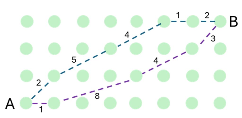
Flight routing is much more involved than this. Not all nodes / edges are available (Danger Areas) or have complicated rules associated with them: useable for different times, altitudes and directions. Flight routing is part of flight planning, which involves other aspects – calculating fuel needed for a trip, ensuring regulatory compliance etc. See https://en.wikipedia.org/wiki/Dijkstra%27s_algorithm for a good description of Dijkstra’s algorithm.
Route availability
Route availability refers to routes that are published as being subject to traffic flow rules defined within the ‘Route Availability Document’ (RAD). Originally updated every 28 days, RAD updates are now almost daily. The RAD was introduced in 2006 and has played an important role in standardising and protecting routes from overload. It has grown to control free route airspace and fine tune flow management. Indeed, early experience with FRA led to the realisation that RAD restrictions could be used to manage the flow of traffic into and out of FRA at specific points.
Flight planning companies have two concerns though. The first is that the effect of RAD restrictions in FRA is to imitate the previous fixed route structure. This gives rise to the second concern, that growing complexity and almost daily changes to the RAD make it difficult to integrate changes into their databases. This can lead to errors when their customers’ flight plans are submitted through the IFPS, which cause flight plans to be rejected. Airlines will then fall back on ‘company preferred routes’, which are static and suboptimal for the day of operation.
Flight efficiency measurement
By measuring flight efficiency, ANSPs will know that they are delivering the optimal conditions for airline flight planning. This is currently measured with distance-based horizontal flight efficiency (HFE).
Air distance metric
While the great circle is the shortest distance, it is not always the shortest time through the airspace, i.e. when there is a head wind. What is confusing about directs is that they look the most efficient on the map but often they aren’t. If they were, then there would be no need for wind considerations in flight planning. To understand wind-based routing we created the ‘air distance’ metric, which accounts for the wind vectors along the flight track.
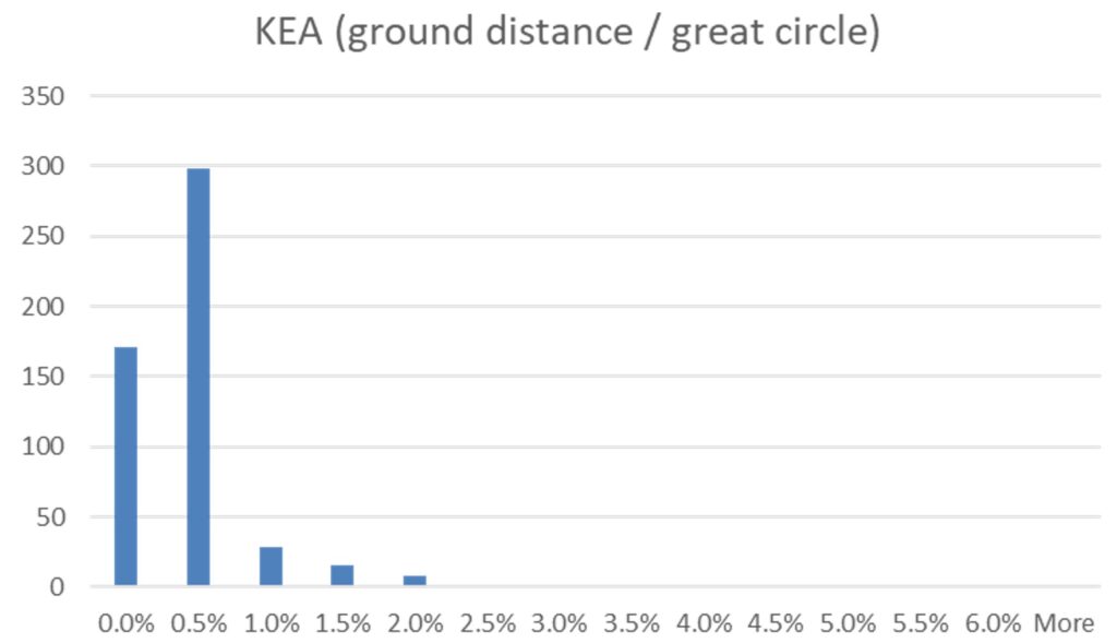
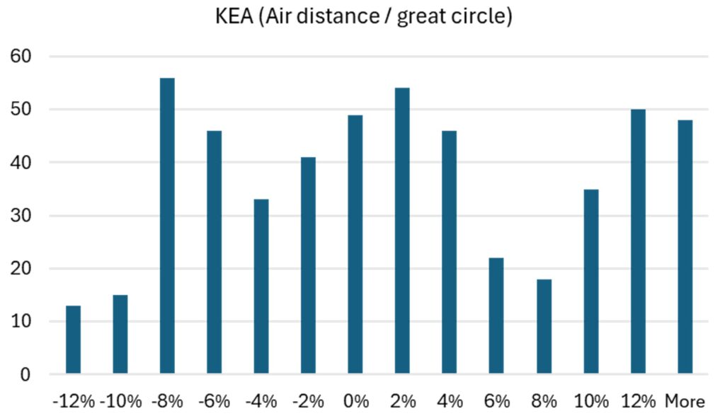
To better scope the issue, we have calculated the actual horizontal flight efficiency (HFE) known as ‘KEA’. This indicator compares the ground tracks (GD) with the great circle distance (GC) as flight inefficiency = GD/GC -1. From a sample of 526 flights from the 25 Jan data, the flight inefficiency varies as shown in the histogram below, where 89% of the flights were within 1% of the great circle distance. This is impressive track keeping born of the age of PBN.
We can use air distance (AD) in the same way, calculating flight inefficiency as AD/GC-1. The following histogram results, showing a wide distribution where ~40% of the flights had an air distance less than the great circle due to tail winds and the remainder ~60% had air distances greater than the great circle due to head winds.
Knowing the air distance would normally give us insight into the flight plan, e.g. why was one route taken over another? But when most flights are taking a direct, does this mean a direct was always the best route? We think this unlikely, and more likely that the multiple complicated factors involved in flight planning now constrain free routing to direct only.
It is likely that distance-based KEA is not an accurate measure of flight efficiency for calculating the benefits of free routing. Aircraft use fuel in accordance with how long the engines run for, not the distance over the ground. When HFE/KFE was introduced, it was a good high level indicator, but it was never intended for operational problem solving.
Conclusion
Free Route Airspace hasn’t been implemented as we expected, but rather as ‘direct’ route. This has arisen from three main factors:
- The difficulty for computer flight planning systems to model and determine user-defined waypoints and segments for a given day of wind conditions, alongside the myriad other roles of these advanced automation systems.
- The ever growing complexity from constraining traffic flows through the RAD.
- The measurement of flight efficiency according to the ground track, not the flight time.
Measuring the route system with distance no longer makes sense while striving to increase real flight efficiency for net zero targets. Worse than this, it makes direct routing look better than wind-based routing.
In summary, the current situation is that the ATM system is inadvertently constraining traffic flows to be less efficient while we have a measurement method that makes inefficient routes look efficient.
Our conclusion is that we need to revisit how we design FRA and consider how we help the flight planning process produce better outcomes for airlines. This could even mean adding waypoints and segments back in, but does not mean we have to go back to the fixed route system.
- Gaxiola C. FRA CBA study. PhD Thesis. 2019 ↩︎
- https://www.eurocontrol.int/concept/free-route-airspace ↩︎