The European Commission’s PRB and EUROCONTROL’s PRC have just published a joint study on the ‘actual benefits of Free Route Airspace’ (FRA). This tallies with Airspace Unlimited’s findings published in January, evidenced by our industry consultations and advanced analytics.
The good news is that the direct-route only implementation of FRA is beneficial; the study finds that 50% of airspace users have experienced a reduction in ‘actual fuel burn’, with Italy and the SECSI FRA region most commonly cited.
While the PRB/PRC study is largely positive, the implication to airlines for direct-route only implementation remains. Our simulations show that there is an opportunity for an increase in the current benefits to airlines by 3-5 times what they are now. Our understanding of the issues across flight planning to ATM processes has enabled us to outline an ATM data service to deliver these extended benefits.
This article shows what we think the key PRB/PRC insights are, but some background first.
Background
First, a quote from @Achim Bauman of @A4E: “If airlines think about optimising airspace a simplified statement is to let us ‘fly as the wind blows’.”
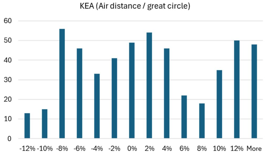
Air Navigation Services (ANS) and their regulators have traditionally measured flight efficiency with reference to the ground track. But fuel burn is proportional to the time the engines are running, not the distance over the ground.
But in ANS, we assume that the direct ‘great circle’ is the most efficient, and that inefficiency is the percentage deviation from it. Another quote from Achim: “Unfortunately, the misconception of ‘direct route = most fuel-efficient route’ refuses to go away.”
We’ve been wondering about Free Route Airspace (FRA) for several months and have shared our sensemaking with around 40 experts in airlines, ANS providers (ANSPs), CFSPs, Eurocontrol etc.
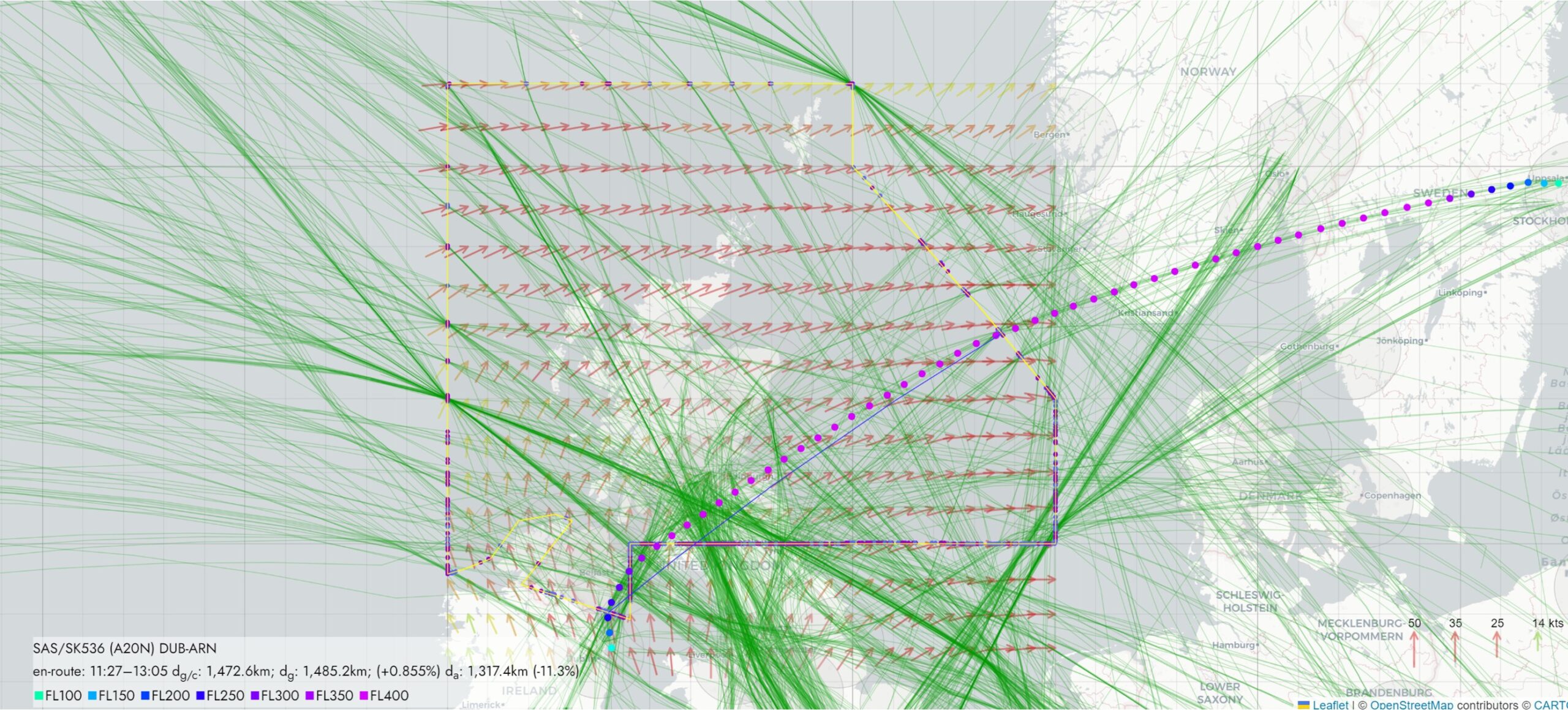
What we found is that most flights within FRA are direct-route only, which limits the benefits. Free route requires the possibility for airlines to route via intermediate (published or unpublished) points. Under the Single European Sky, direct route was mandated for 2018 and free route by 2022.
Our take-aways from the PRB/PRC study
1. “Where weather is a significant factor, it should enable airspace users to optimise their route to make best use of weather conditions”.
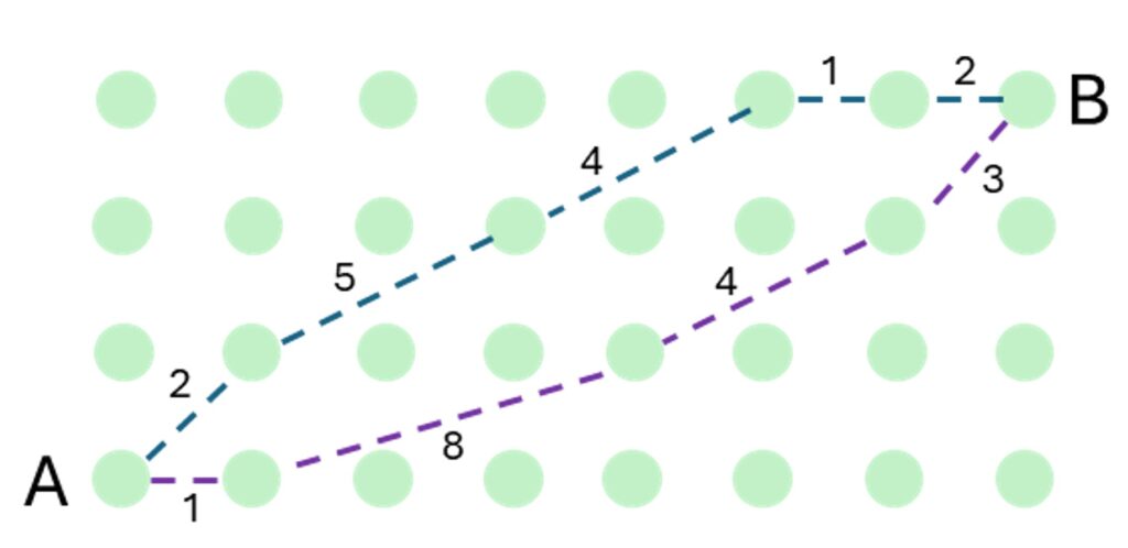
=> In fact, weather and specifically winds are always a factor in flight planning, it’s how the algorithms work through ‘shortes path’ weighted graphs (Dijkstra etc.). In ATM we design in still air and operate in winds, future airspace designs need to consider this.
2. “Optimal routings should reduce the time an aircraft spends in the air.”
=> Yes, it’s flight time that burns fuel, not ground track distance.
3. “…the Regulation does not prescribe how FRA should be implemented or define the level of flexibility to be afforded to airspace users planning and flying through the airspace”.
=> The Common Project regulation was light on detail, but the intention must have been clear. The widely implemented ‘Borealis’ CONOPS details interim way points. National regulators and the EC may need to clarify their expectation for compliance with the regulations, but it is unlikely they will need changing.
4. “While all aircraft flying in FRA are technically flying freely … in practice the flexibility is limited by the choices of the airspace users and the support available from the CFSPs.”
=> CSFPs have not implemented user-preferred points, creating up to 400km directs. This can be addressed quickly by ANSPs in an ATM data service. But please let’s not chuck some random waypoints back in and make things even more complicated than they are.
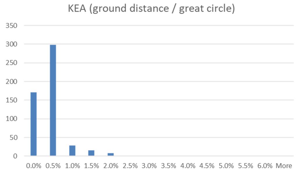
5. “A presentation from ENAV … noted that only 8% of aircraft, equating to one airline, were flight planning using free route airspace in this area”.
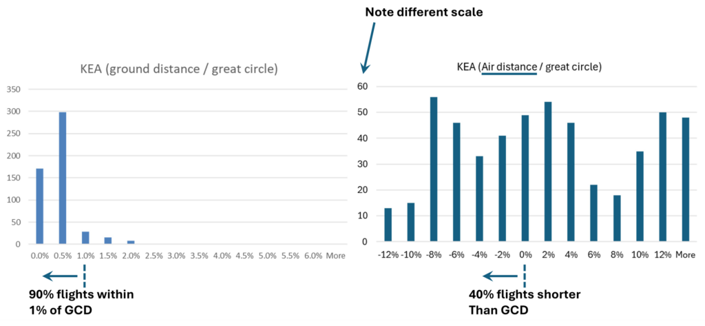
=> We observed that 90% of flights within the Scottish FRA were within 1% of the great circle, i.e. they were flying directs not free routing. The industry needs to switch to better performance indicators and fast – our ‘Air Distance’ is contender and we are keen to collaborate on this.
6. “Maximising the benefits of FRA would lead to a significant increase in required computing power and time required for the route calculations. Therefore, CFSPs make a compromise between time required and the optimisation of the proposed routes, which CFSPs suggest achieves the majority of the benefits of FRA.”
=> This is a core issue. CFSPs did not implement user-preferred points because the processing time was too much. This is why we see an ATM Data Service as a quick solution.
Conclusions
Whether or not the current implementation meets the regulations, the benefits to airlines lie in implementation of user-preferred points, the actual ‘free-route’ part of Free Route Airspace.